


La Ronde du Crêt Cret Monniot Noire

i20
User
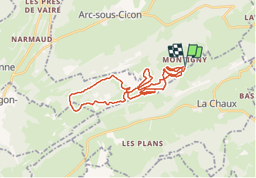

Length
16.9 km

Max alt
1116 m

Uphill gradient
368 m
Km-Effort
22 km

Min alt
978 m

Downhill gradient
371 m
Boucle
Yes
Creation date :
2021-01-02 09:04:52.639
Updated on :
2021-01-02 11:03:18.254
1h57
Difficulty : Very easy

FREE GPS app for hiking
 SityTrail
IGN / Geographical institutes
SityTrail Plus
The world is yours!
About
Trail Cross-country skiing of 16.9 km to be discovered at Bourgogne-Franche-Comté, Doubs, La Chaux. This trail is proposed by i20.
Positioning
Country:
France
Region :
Bourgogne-Franche-Comté
Department/Province :
Doubs
Municipality :
La Chaux
Location:
Unknown
Start:(Dec)
Start:(UTM)
303875 ; 5212335 (32T) N.
Comments